North Coast Northern Rivers Floor Level Surveys
Contact point

Client
NSW Reconstruction Authority (NSW RA)
Services provided
Mobile laser scanning, manual surveys, data quality assurance and project management
Background
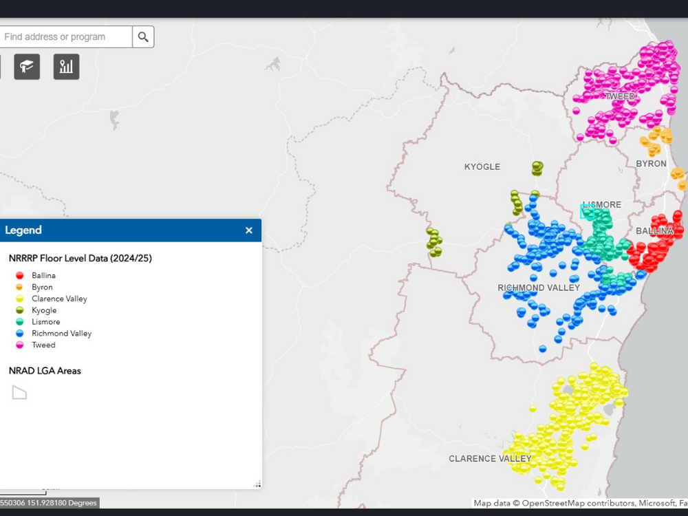
The Northern Rivers Floor Level Surveys Program was launched to collect accurate floor level data across seven local government areas in the Northern Rivers region. This data plays a vital role in enhancing flood resilience.
This project received funding from the Australian Government through the Northern Rivers Recovery and Resilience Program, administered by the NSW RA, and delivered by NSW Public Works (PW).
Key facts
- Total surveys completed: 12,308
- Completion date: 2025
- Mobile laser scans: 8,953
- Local government areas covered: 7
- Assist local government with flood evacuation modelling
Our role
PW played a crucial role in delivering the program.
To undertake the surveys, PW engaged a specialist contractor through an invited tender process under a Consultancy Services Agreement. The contractor was tasked with surveying 12,308 residential and commercial properties located in flood-declared zones across seven local government areas. These zones included areas subject to 1:20, 1:100, and 1:500 year flood events, as well as the probable maximum flood level.
Two survey methods were employed:
- Mobile Laser Scanning technology, which combines LiDAR and GPS equipment mounted on a vehicle. This method captured accurate 3D survey cloud data and habitable floor levels of dwellings in urban areas while the vehicle was in motion. It was used to complete 8,953 surveys.
- Conventional surveys were carried out for 3,355 properties, including those larger than 10,000 square metres, to ensure full and reliable data coverage.
Each property was surveyed at two points:
- top of kerb
- habitable floor level of the dwelling(s)
PW managed the full lifecycle of the project, including fieldwork coordination, data validation, and quality assurance. Our in-house GIS and Spatial Services team worked closely with the contractor and the NSW RA to ensure the data met all required standards prior to submission.
We also facilitated access coordination by liaising with local councils, residents, and strata managers. This included providing advance notice to landholders and directly engaging with residents and strata companies to address queries and secure access permissions on behalf of the contractor.
Outcomes
The project delivered 12,308 validated floor-level surveys across seven local government areas. This data has been provided to NSW RA and forms a critical foundation for flood risk management and future planning.
The survey data has also been shared with each of the participating councils in the Northern Rivers. Councils have reintegrated the data into their flood evacuation modelling. In addition, the floor level data supports other NSW RA disaster resilience initiatives, including the Resilient Homes Program (raise and retrofit) and the Disaster Adaptation Plan.
Key achievements include:
- Effective use of LiDAR technology
- Successful manual surveys in complex terrain
- A rigorous quality assurance process led by PW’s GIS and Spatial Services team. This ensured the accuracy and reliability of the data throughout the project.
By strengthening the region’s ability to anticipate and respond to flood events, the project contributes to community safety and long-term resilience.