Multiple regions Property Assessment – 90-day project
Contact point

Client
Department of Primary Industries and Regional Development (DPIRD)
Services provided
Property database creation and dashboard development showing income opportunities for land
Background
DPIRD has a diverse land portfolio managed by different agencies recorded using different approaches and systems. The DPIRD 90 Day Project was short-term high-profile project to identify the best opportunities for generating income in new or different ways across its agencies.
DPIRD needed a single source of truth to view its overall land portfolio, and, required evidence-based methods for modelling income potential opportunities like Biodiversity Offsets, housing and carbon credits to compare against modelled existing income like agriculture.
Key facts
- Property database containing ~7,000 properties from Local Land Services, Soil Conservation Service, Ag & Bio, and NSW Public Works.
- Current income for each property showing 11 different agriculture applications.
- Potential income using land for Housing, Biodiversity Offset, Carbon Credit, and Renewable Energy.
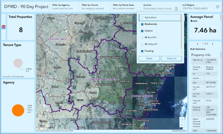
- Interactive Project dashboard with filters, searches and updates.
Our role
NSW Public Works' GIS team applied data processing and warehousing methods to create an authoritative DPIRD property database. For each property, a link is maintained back to the original data source. Each dataset had a unique structure, requiring field and value harmonisation so we were required to use modelling software to amalgamate fields and tables into a single dataset table representing all 7,000 properties. The new property data table was then verified by referencing the current NSW state cadastre (authoritative property dataset for the state) to ensure every DPIRD property could be accurately mapped. The scripted approach is repeatable and can be updated as data or requirements change, is repeatable and can be updated when requirements or the data changes.
Working out the potential income opportunities for each property required extensive analysis using the best available data from agencies and authoritative sources.
Potential biodiversity offset income was calculated by matching plant community types and areas from either field station-specific reports (where available) or the State Vegetation Type Map to the Biodiversity Offset Transactions Register.
Current agricultural income was determined for various agricultural applications using linear interpolation between reference lines and points.
The approach used could be applied to consolidating local government property registers or creating single property registers for merged Councils.
Housing, renewable energy and carbon credits income values were provided by respective agencies from prior or current studies.
Outcomes
A single source of truth property database was developed and accepted. Current and potential income opportunities were determined for every property.
A GIS dashboard enabled the identification and review of high-priority properties based on potential income. A summary Excel output from the property database supported independent verification of prioritised properties for future income.